
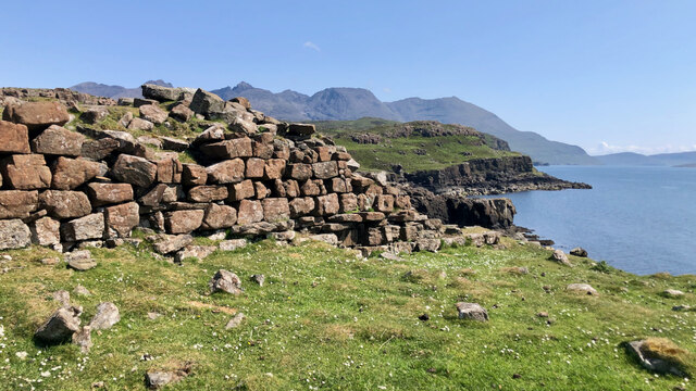
 Rubh’ An Dunain Galleried Dun -Photo © Mick Garratt (cc-by-sa/2.0)
Rubh’ an Dùnain, a secluded peninsula on the West Coast of the Isle of Skye, holds a rich history. Situated between Loch Brittle and the Sound of Soay, this headland is a treasure trove of archaeological remains. It offers a window into a time when Norse settlers made Skye their home. Centuries ago, Vikings steered their ships along this same coastline. Before them, Neolithic communities gathered food from these waters. In the Iron Age, people forged iron in nearby caves. Time has passed, but the landscape remains much as it was.
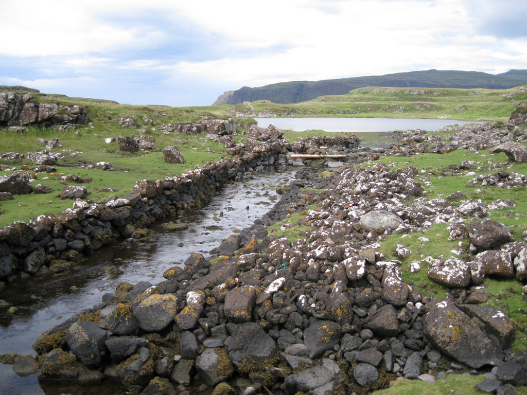 Naust and canal, Loch na h-Airde Photo © Richard Dorrell (cc-by-sa/2.0)
The Viking Canal and Loch
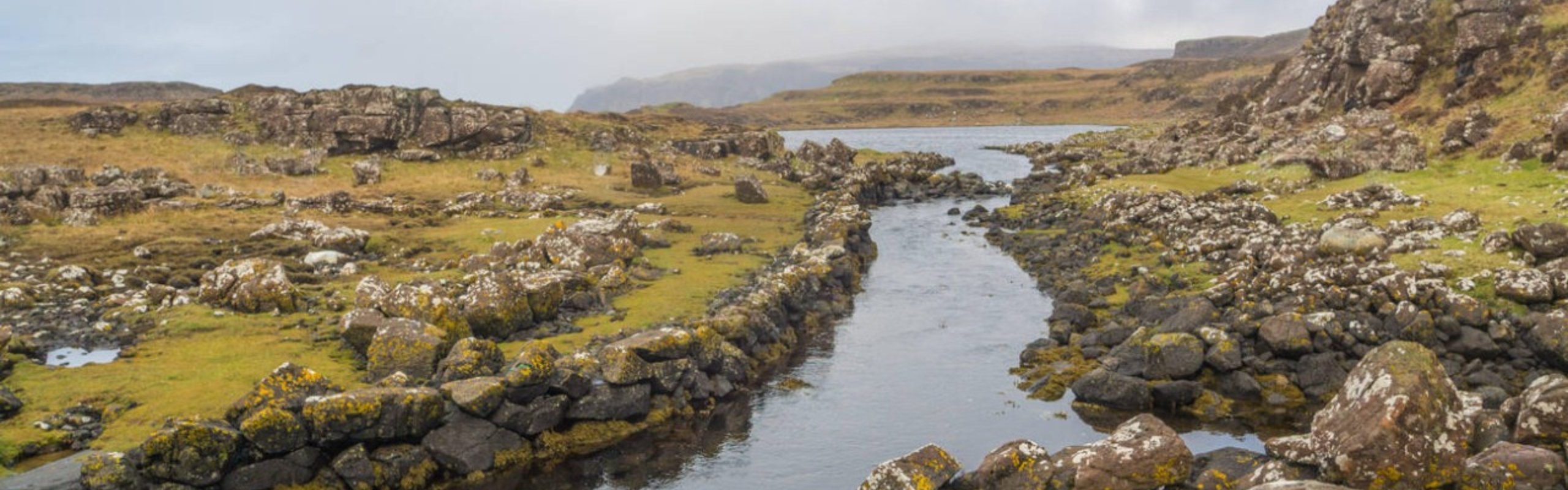
At the heart of Rubh’ an Dùnain lies an ancient, stone-lined canal linking the sea to Loch na h-Airde. This canal, believed to date from the Viking era roughly 900 years ago, was likely used to shelter longboats. The loch itself served as a hidden harbor, a strategic location for Norse raiders who sought refuge from the sea. This engineering feat, with its stone walls still visible today, is a rare example of Viking maritime infrastructure in Scotland.
The canal demonstrates how the Norse people, known for their seafaring prowess, adapted to the natural landscape of Skye. By creating a sheltered inlet, they could protect their prized birlinns (boats) from the harsh Atlantic weather. Standing at the site today, one can easily imagine Viking ships being dragged through the canal to shelter.
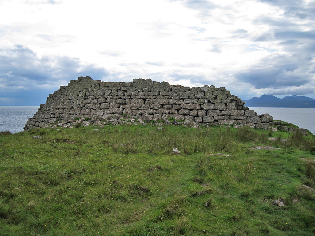 Rubh an Dunain Fort – Photo © Richard Dorrell (cc-by-sa/2.0)
The Iron Age Promontory Fort
The promontory fort at Rubh’ an Dùnain predates the Viking presence, originating in the Iron Age. It occupies a strategic position on a cliffside, with steep drops to the sea providing natural defenses on three sides, while a well-built stone wall shields the landward approach. The fort would have offered both protection to its inhabitants and control over the coastline below.
Though erosion over the centuries has significantly reduced both the fort’s structure and the surrounding promontory, the remains still provide sweeping views across Loch na h-Airde and the Sound of Soay. From this vantage point, early settlers would have watched for approaching threats and navigated their daily lives.
The Multi-Purpose Cave
A cave at Rubh’ an Dùnain, excavated in 1932, reveals a fascinating history of varied uses across different eras:
- Neolithic Period: Initially served as a stone-knapping workshop, with evidence of tool-making from beach pebbles and bloodstone brought from the nearby island of Rum
- Iron Age: Later repurposed as an iron-smelting site, containing a small furnace and significant quantities of iron slag
Despite these industrial uses, the cave was not a permanent dwelling, as no hearth was discovered. Evidence suggests its occupation was likely seasonal or occasional.
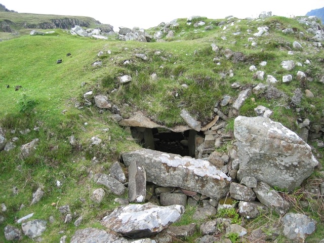 Chambered Cairn at Rubh’ an Dunain – Photo © John Allan (cc-by-sa/2.0)
The Ancient Chambered Cairn
The chambered cairn (approx: ///subtitle.went.beanbag) at Rubh’ is a quiet relic of Skye’s Neolithic past. It’s roughly 20 meters wide and 3 meters tall. The cairn once had a lintelled passageway leading inside, though the entrance has since collapsed. Despite this, the open roof offers a clear look into the inner chamber, revealing the neatly arranged stonework. Excavations in the 1930s uncovered six human remains, along with fragments of pottery, flint, and quartz tools. Built with stones likely gathered from nearby beaches, the cairn still tells the story of those who used it as a burial place over 5,000 years ago.
The Highland Clearance Settlement
The most recent chapter in Rubh’ an Dùnain’s history is marked by the ruins of a 19th-century settlement. At its center stands Rhundunan House (///scatters.vowed.candle), the former home of the MacAskill Clan, which contrasts with the smaller cottages of the surrounding village.
This community thrived until the 1860s, when, like many areas in the Highlands, it fell victim to the Highland Clearances. The local population was forcibly displaced to make way for sheep farming, leaving their homes and lands abandoned. Today, these crumbling, overgrown buildings serve as a poignant reminder of the families who once lived and worked here, their lives disrupted by the broader economic and social forces that reshaped the Scottish Highlands.
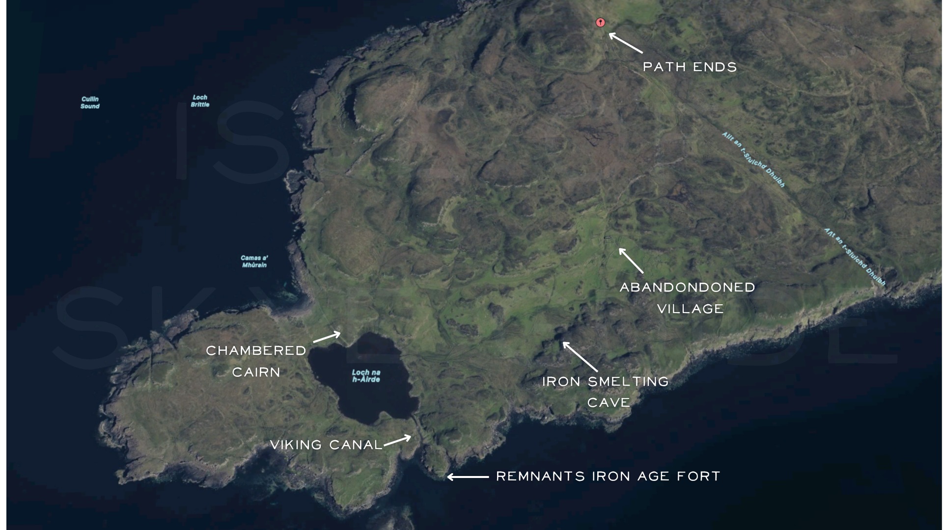
Key Points for Getting to Rubh’ an Dùnain
- Starting Point: The walk begins at the Glen Brittle campsite, which offers ample parking and, in the summer, a small shop. Start by following the path behind the toilet block.
- Initial Path: Follow the dirt road that runs parallel to the shoreline of Loch Brittle. This track is mostly easy to follow, but it crosses several burns from the Cuillin, which may become difficult to ford in heavy rain.
- Reach the Boundary Wall: The track leads to a prominent boundary wall at ///beards.watches.subway. Just before the wall, turn left and cross through a clear breach.
- Navigating to Rhundunan House: After crossing the wall, the path becomes less distinct. Head directly towards the ruins of Rhundunan House (///scatters.vowed.candle), once the home of the MacAskills before the 19th-century clearances.
- Visit the Dun: Continue past Rhundunan to the Fort at Rubh’ an Dùnain (///copes.kilowatt.constrain), a well-preserved ancient fort perched on a cliff edge. Below the dun, you’ll find the stone canal (///sandals.grudge.starlight) connecting the sea to Loch na h-Airde.
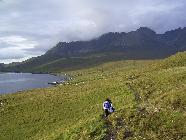 Path Back to Glenbrittle © Tony Teperek (cc-by-sa/2.0)
Key Considerations for the Walk to Rubh’ an Dùnain
- Walk Length: The round trip from Glen Brittle to Rubh’ an Dùnain is about 12 km (6 km each way). Depending on pace and stops, it can take around 4 to 5 hours to complete.
- Burn Crossings: The route crosses several burns flowing from the Cuillin mountains. While usually easy to cross, they can become impassable after heavy rain or in times of spate. Be prepared to find alternative crossings if needed.
- Boggy Sections: Expect some boggy areas, especially after leaving the main track and heading towards Rubh’ an Dùnain. Waterproof boots and gaiters are recommended, particularly after rain.
- Navigation: The path is relatively clear until you pass the boundary wall. Beyond this point, navigation can be tricky due to the less distinct path. Having a map and compass or a GPS device is advisable, especially in poor weather.
- Wildlife and Scenery: The area is rich in wildlife, with chances to spot otters, seals, and birdlife along the coastline. The views across the Sound of Soay and Loch na h-Airde make the walk rewarding despite the terrain challenges.